The radioactive substance pollution of Fukushima Prefecture due to Fukushima Daiichi nuclear power plant accident
−The actual condition of the pollution seen from the inhabitant of the polluted area−
Shigeki CHIBA (Ono-Hirata High School, Fukushima Prefecture)
Abstract
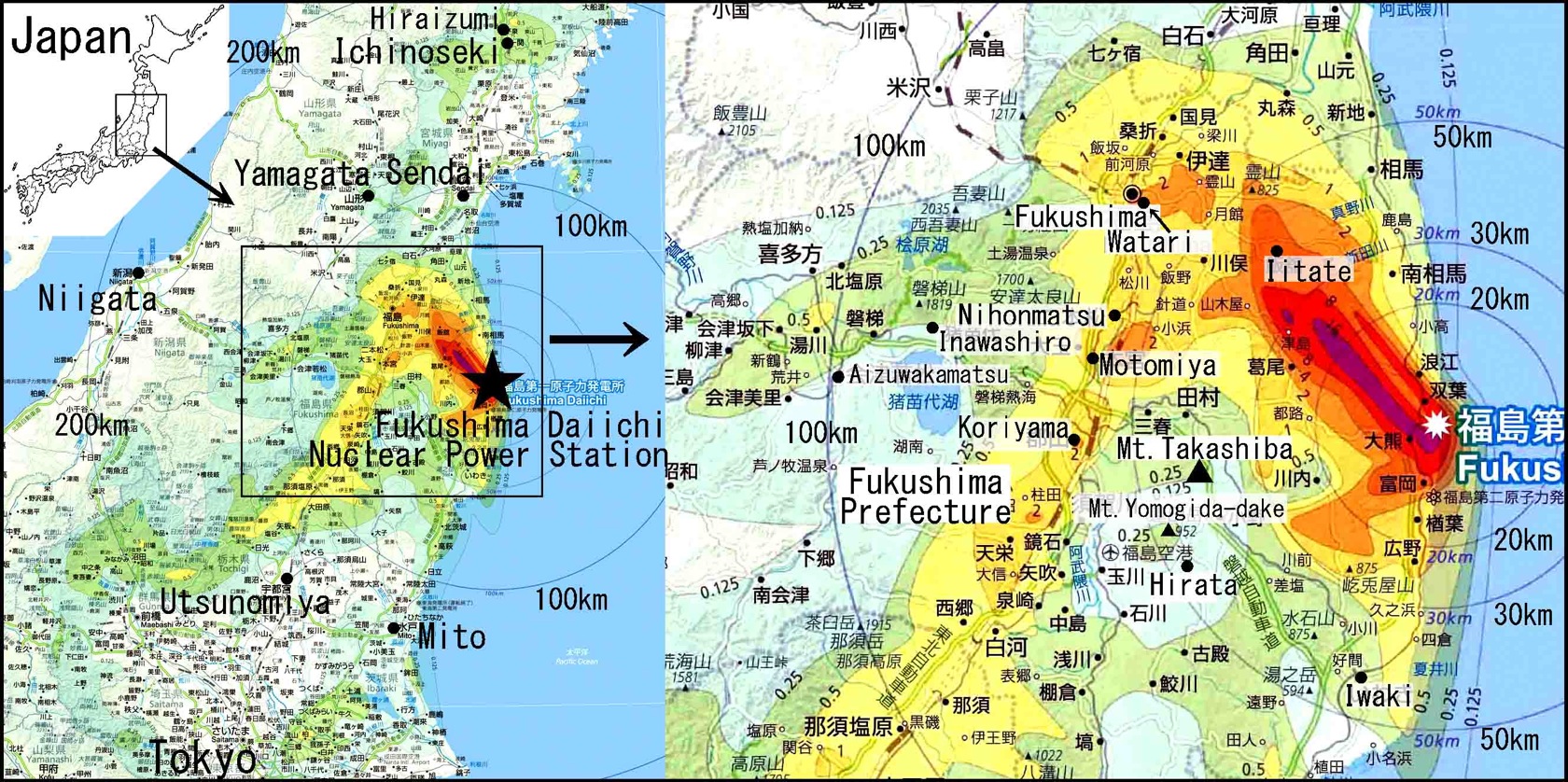 |
| Fig. 1 The contamination of the radiation material Fukushima Daiichi accident–Hayakawa (2013) is used. *click to expand »black-and-white diagram |
The huge earthquake (M 9.0) occurred in the Pacific coast of northeast Japan at 14:46 on March 11, 2011. Immediately afterwards, the Fukushima Daiichi nuclear plant was destroyed: Hydrogen explosions occurred in the buildings of the Nos. 1, 3 and 4 reactors, and fire broke out the building of the No. 4 reactor. By the destruction of the nuclear power plant, the large amounts of radioactive substance were scattered in the atmosphere and Ocean. As a result, the ground in Fukushima Prefecture was heavily polluted with radioactive material (Fig. 1).
The author Chiba carefully measured the radiation dose on the land surface at the several areas in Fukushima Prefecture. Chiba intensively surveyed the occurrence of radioactive contamination soil and Chiba took notice the black material showing extraordinarily high radiation.
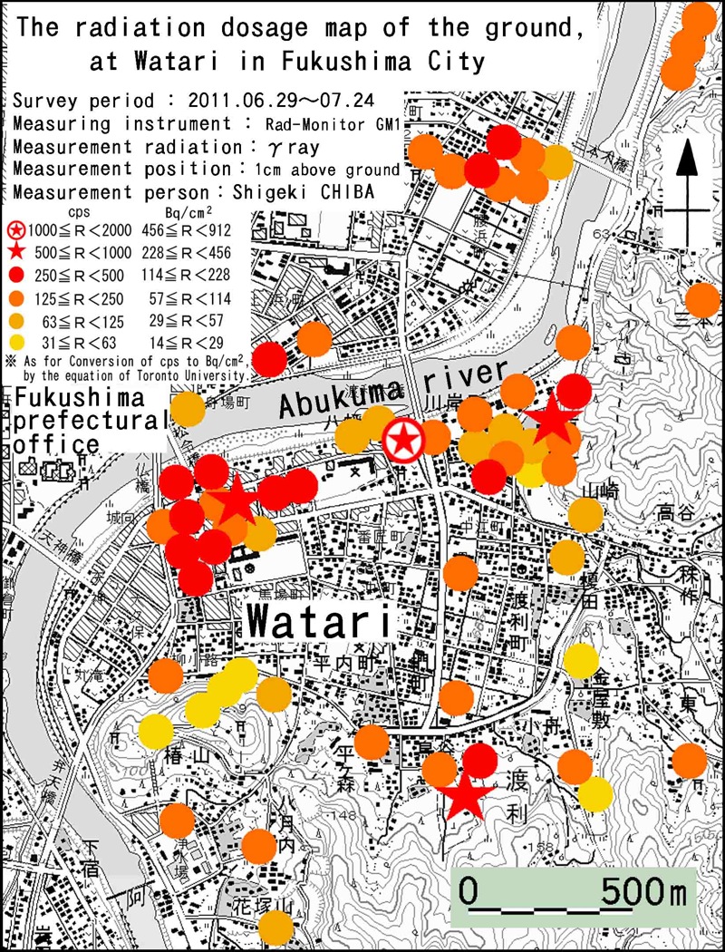
Chiba purchased a dosage meter in June, 2011, and measured the surface radiation dose of land around the Fukushima City district from June through July, 2011 (Fig. 2). The highest reading of the radiation dose was 1300cps in Aza Yahata-cho, Watari, Fukushima City (Rad-Monitor GM1). In addition, in Watari, Fukushima-City, a radiation dose of between 125 and 500cps was recorded at many locations.
In August, 2011, Chiba also measured the air radiation dose of Hirata Village in Fukushima Prefecture’s Nakadohri area located 40 km to the southwest of the reactors. The air dose of radiation of Hirata Village was 0.15 to 0.30μSv/h(at the height 1m) in the lowlands, and was 2.5μSv/h(at the height 1m) near the top of local mountain Yomogida-dake (Fig. 3).
 |
 |
 |
| Fig. 2 The radiation dosage map of the ground at Watari in Fukushima City–Measurement using Rad-Monitor GM1. The 1/25,000 scale maps of the Geospatial Information Authority of Japan (GSI) is used. *click to expand »black-and-white diagram |
Fig. 3 The radiation dosage map at 1m above the ground at Hirata Village in Fukushima Prefecture–The 1/25,000 scale maps of the Geospatial Information Authority of Japan (GSI) is used. *click to expand »black-and-white diagram |
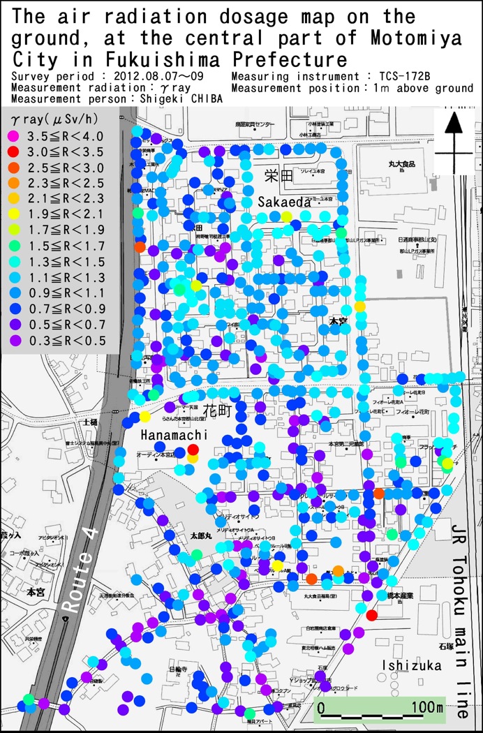
Fig. 4 The air radiation dosage map at 1m above the ground at the central part of Motomiya City in Fukushima Prefecture–The map by Zenrin is used. The usage is approved by the GSI “H13 toshi. No.8”. *click to expand »black-and-white diagram |
In August, 2012, Chiba measured the air radiation dose of a central part of the Motomiya City district, 57.5 km to the northwest of the reactors (Fig. 4). This was for the purpose of investigating the movement and accumulation of radioactive material by meteoric water. The recorded radiation dose was from 0.3 to 0.7μSv/h(at the height 1m) in the southwestern section of the sampled area, and from 0.3 to 1.9μSv/h(at the height 1m) in the northeastern section. The sampled area slopes down from southwest to northeast, suggesting that radioactive material was carried downhill (northeastward) by meteoric water. Several high radiation sites (hot points,1.7∼3.5μSv/h) were recorded locally, suggesting that radioactive material was accumulated in hollows and areas of depression.
Chiba noticed common characteristics among many high radiation sites recorded during the investigation of the Fukushima City district. The soil at such locations was often black in color, and patterned with hexagonal cracks in its surface. In particular, the hot points in Iitate Village, which show especially high radioactive doses, was remarkable for its deep-black color and the clearly defined pattern of hexagonal cracks on its surface, resembling silk crape (Fig. 5). It was 216Bq/cm2 (2.16×10⁶Bq/m2) when I measured a radiation dose of the high radiation soil surface by CoMo170, at July 7, 2013. And, the radiation dosage of this soil is 134Cs;4.3×10⁶Bq/kg,137Cs;1.0×107Bq/kg(Sampling by Shigeki CHIBA at April 30, 2012. Measuring by Hiroaki KOIDE at July 10, 2013).
And, the soil which takes out these high radiations is moved with rainwater (Fig. 6).
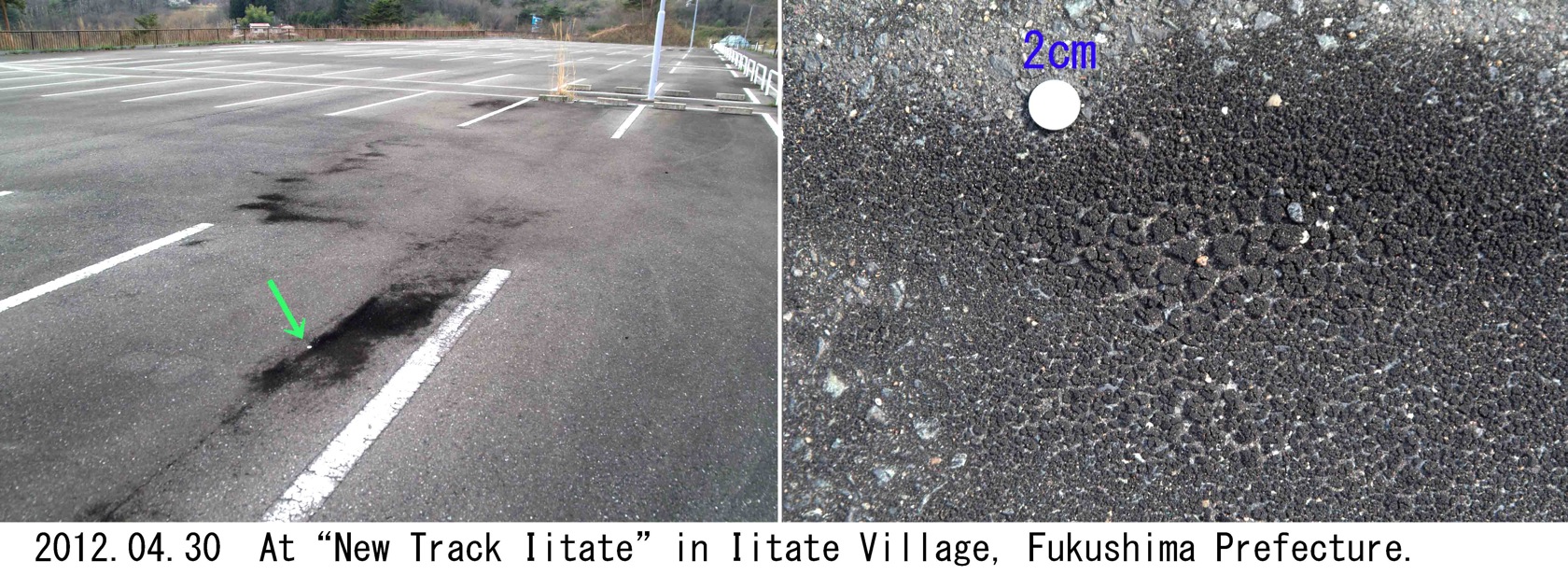 |
| Fig. 5 The high radioactive contamination soil at “New Track Iitate” in Iitate Village, Fukushima Prefecture–The radiation dosage of the ground is 80,000 cpm (LUDLUM3+44-9). The radiation dosage at 1m above the ground is 3.24μSv/h(ИP-001). Scale is 2 cm in diameter.*click to expand »black-and-white picture |
 |
| Fig.6 The sliding of the high radioactive contamination soil at Iwasaki-cho in Watari, Fukushima City *click to expand »black-and-white picture |
 |
| Fig. 7 The soil of high radiation that exists in a forest —Mt.Takashiba in Fukushima Prefecture− *click to expand »black-and-white picture |
In addition, high ground radiation was also recorded in Inawashiro Town, where a low dose of radiation was recorded in the air. Ground with high radiation levels was also recorded in Ichinoseki-City in Iwate Prefecture, about 160 km away from the Fukushima Daiichi nuclear power plant.
These results are mentioned in detail by Chiba et al. (2013), but further investigation into radiological distribution in the forest area has recently been conducted. It is not written in the conventional thesis as far as the author knows it, and the contents of the following sentences become the first report. In this investigation, Chiba has discovered the soil which emits a high radiation under the tree in the forest at Mt.Takashiba in Fukushima Prefecture (Fig. 7). This soil has the hard surface of black color and dull luster with hexagonal desiccation cracks, and its inside is full of spongy cavities. It is called tentatively as “The shield-shaped soil”. In this place, the air dose of radiation was 0.50μSv/h at the height of 1m, and the surface radiation dose of this soil was as high as 8.07μSv/h. And, the radiation dosage of this soil is 134Cs;1.3×10⁵Bq/kg,137Cs;3.2×105Bq/kg(Sampling by Shigeki CHIBA at May 18, 2013. Measuring by Hiroaki KOIDE at July 10, 2013).
[Reference]
Shigeki CHIBA, Kanenori SUWA and Kazuhiro SUZUKI(2013): Occurrence of radioactive contamination soil, especially of black material on the field in Fukushima Prefecture. Summaries of Researches Using AMS at Nagoya University. XXIV. 78−96. (in Japanese with English abstract)
(2013.7.15)